| |
Geography:
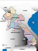
Laos is located in South East Asia. Most of its 1,000 kilometres
territory is a tropical zone.
The country is slowly emerging from a long isolation, created in
part by its extremely broken relief. Mountains and rivers make up
the main features of this country. Laos can be divided into three
main areas:
- The Mekong valley where, from north to
south, the bulk of the population and cultivated land (paddy fields)
can be found. The Mekong River, which runs for more than 1,800 kilometers,
fertilises a large portion of the plains in the Western part of
the country. Together with its main tributaries (Nam Ou, Nam Khan,
Nam Tha….), it has long been the main means of communication
and transportation for the country.
- The north is made up of very steep mountain
ranges that are mostly covered by forests. These mountains often
rise up over 2,000 meters, peaking with Mount Phou Bia at 2,820
meters. To the north of this peak lies the country’s biggest
plateau, the famous Urn Plain, renown as much for its mysterious
pre-historic urns as for its role in the Vietnam War.
- The Annam Trung Son range of mountains
which runs parallel to the Mekong River with its jagged peaks reaching
2,500 meters. Nestled in the midst of this range is the Khamouane
plateau, known for its impressive limestone landscapes. The capital
is Vientiane (population 300,000) then by order of size: Savannakhet
(pop.: 60,000), Pakse and Luang Prabang (pop. 25,000).
 |
Weather:
There are only two seasons in Laos: the rainy season (June to mid
October) with rainfall that vary considerably according to latitude
and altitude, and the dry season for the rest of the year. It should
be noted that temperatures can be quite low in the north, especially
from mid December to the end of January; during this period temperatures
can fall to around 0° C in the provinces of Xiang Khouang, Phong
Sally or Oudomxay.
|


;)
;)
;)
;)
;)
;)
;)
;)
;)
;)
;)
;)
;)
;)